A unique item of radio navigation history

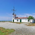
The photograph above was taken in September 1986 in Thessaloniki and shows a directional longwave maritime navigation beacon. At the time the photo was taken, the station was manned by officers and NCOs of the Hellenic Navy LighthouseService. This station was listed in an old radiobeacon list as No 1261 and transmitted on 308 kHz with a power of 200 W. Its location was 40d 36' 40" N - 22d 57' 05" E and the fixed bearing of the antenna 50 degrees towards the beacon. Receivers located north of the beam received the letters TN while receivers south of the beam the letters TS, while on the beam the full id TNTS was heard.
A similar station was located at the mouths of River Axios, on Kavouras Island (40d 30' 42" N, 22d 44' 54" E), with a bearing of 340 degrees, sending AW west of the beam and AE east of the beam. Receivers sighting the beacon at 340 degrees heard the full id AWAE. The AWAE station was listed as No 1263 in the radiobeacon index and transmitted on 287.3 kHz with 200W. This beacon is also listed by J. Trochimczyk in his "Handbuch der Funknavigationshilfen". Both stations are marked on the "North Aegean Sea" (no 47) 1:500,000 chart issued by the Hellenic Navy Hydrographic Service.
These stations operated only during dense fog conditions and were coordinated on VHF marine channel 22 (this is normally a duplex channel, possibly there was a repeater on the frequency).
In addition to the beacons, there were two RACON (radar transponders) as follows:
RACON "T" 40d 35' 00" N - 22d 55' 17" E (Cape Mikro Emvolo)
RACON "X" 40d 30' 42" N - 22d 44' 54" E (Kavouras Island)
At the Cape Mikro Emvolo location there was a longwave receiver which was activated by the TNTS beacon and set off a foghorn.
Navigation using the beacons
 |
| Extract of chart with added navigation info |
These beacons could be used to enter the Thessaloniki Harbor during dense fog conditions avoiding the navigation hazard of the shallow waters at the mouth of River Axios and Cape Megalo Emvolo.
The skipper of a ship arriving from the Southeast would follow a west course listening on the "AE" signal on 287.3 kHz, until he intercepted the "AWAE" beam. He should then turn North to follow a course of 340 and retune his receiver to 308 kHz, where he would hear the "TS" signal. After intercepting the "TNTS" beam, he would turn NE and enter safely the Gulf of Thessaloniki, following a course of 050 and steering clear of Cape Megalo Emvolo.
This method does not require a DF receiver, a standard LW/MW receiver would do, as long as an accurate compass was available. The associated RACONs would guide in the same way a skipper navigating with radar.
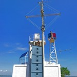
Current system status
 |
| The TNTS beacon in March 2016 |
When a radio listener (SWL) from Thessaloniki visited them around 2000 and enquired about operating frequencies, schedules etc, he got an answer like: "These things are naval secrets!". If someone from Thessaloniki has ever heard these beacons transmitting or has any additional information, please comment at the bottom of this page.
Update 2018-08-18: Two photos of Axios Beacon (AWAE) taken by "Basilpo" in 2008, which appeared on Flickr:
 |
 |
Update 2026-02-09: Aerial view of Axios Beacon (AWAE):
 |
| Axios Beacon on ipernity.com |
References
- Dr. J. Trochimczyk: "Handbuch der Funknavigationshilfen", 2. Auflage, Wilhelm Herbst Verlag, 1985.
- Hellenic Navy Hydrographic Service, Map no 47 (N. Aegean Sea, 1:500000), 1969.
- R. A. Connolly, GI7IVX: "Non Directional Beacons of Europe", 4th ed, 1997/1998.
No comments:
Post a Comment